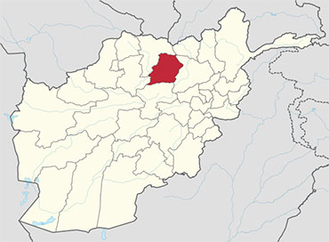
 Samangan is one of the thirty-four provinces of Afghanistan, located north of the Hindu Kush mountains in the central part of the country. The province covers 11,218 square kilometres (4,331 sq mi) and is surrounded by Sar-e Pol Province in the west, Balkh in the north, Baghlan in the east, and Bamyan in the south. The majority of the population here is Uzbek, but there also significant numbers of Pashto and Persian speakers in the province.
Samangan province is divided into 7 districts and contains 674 villages. It has a population of about 368,800, which is multi-ethnic and mostly a rural society. The city of Samangan serves as the provincial capital.
History
The earliest known history of the province is linked to the identification of the Samangan by Aoros Ptolemy as the place of the Varni or Uarni and the fortified city of Samangan on the banks of the Khulm River identical to the Bhaktria regi on the Dargydus river south east of Zariaspa. The ruins found here established the city’s founding by Eukratides, the King of Bactria. It was then known as Edrisi the size of the Khulm city.
Historicity of the Samangan town dates to the time of the Kushan Empire during the 4th and 5th centuries when it was a famous Buddhist centre. Witness to this period is seen now in the form of ruins at a place called the Takht-e-Rostam, which is located 3 km from the town on a hilltop. Arabs and Mongols came to this place when it was already famous as a Buddhist religious centre. Aibak was the name given to this place when, during the medieval period, caravans used to stop here.
Afghanistan has various archaeological sites where caves were hewn out of rocks and inhabited by Buddhists. “One of the most spectacular sites is that of Takth i Raustam, near Samangan (Haybak), north of Hindu Kush passes. It includes a complex of stupa with monastery, hewn out of the rock. Other caves have been found near Jalalabad and at the site of Humay Qal’a southwest of Ghazni.
The Buddhist in Takth i Raustam here in the form of a mound, located on the hilltop, represents the earliest link to the evolution of Buddhist architecture in Afghanistan.
The area was conquered by the Hephthalites followed by the Saffarids who brought Islam. The Samanids took it and controlled it until the Ghaznavids rose to power in the 10th century, they were replaced by the Ghorids. After the Mongol invasion the Timurids took possession.
Between the early 16th century and the mid-18th century, the territory was ruled by the Khanate of Bukhara. It was given to Ahmad Shah Durrani by Murad Beg of Bukhara after a treaty of friendship was reached in or about 1750, and became part of the Durrani Empire. It was ruled by the Durranis followed by the Barakzai dynasty, and was untouched by the British during the three Anglo-Afghan wars that were fought in the 19th and 20th centuries. It remained peaceful for about one hundred years until the 1980s Soviet war in Afghanistan.
Recent History
After the Afghan Civil War, the town of Darra Souf in Samangan Province was occupied by Ustad Mohammad Mohaqiq and the Taliban in late 1999. The Taliban forces gained control of the area from January to March 2000 including nearby Sar-e-Pol and Baghlan provinces, where they were reported to have massacred an unknown number of civilians.
On May 8, 2000, several men from Baghlan were driven up to the Robotak Pass in Samangan province, approximately 20 miles north of the city of Samangan (100 miles south of Mazar-i-Sharif) and were executed, later found by local farmers in shallow graves which the Taliban had dug for them.
After the removal of the Taliban government in late 2001, the Karzai administration took over control of Afghanistan. In the meantime, the International Security Assistance Force (ISAF) established a Provincial Reconstruction Team (PRT) in the province. After getting training by ISAF, the Afghan National Security Forces (ANSF) are providing security for the population of the province.
The province has a fairly good security situation, with the United Nations Department for Safety and Security (UNDSS) reporting a calm and stable condition. However, on 15 February 2011 an ISAF peacekeeper from Finland was killed in a roadside bombing near Samangan City, and on 14 July 2012, Ahmed Khan Samangani, a member of the National Assembly of Afghanistan, was killed when a suicide bomber infiltrated his daughter’s wedding party in the city of Samangan. The bomb also killed the provincial head of the National Directorate of Security (NDS), and 13 other guests, and 60 were injured, including senior police and army commanders. The deputy provincial governor, Ghulam Sarkhi, claimed that the death toll was likely to rise.
Healthcare
Health services provided by the Ministry of Health are fairly basic with 6 health centres and 3 hospitals with 60 beds. They are reasonably well staffed with 21 doctors and 33 nurses. To cater to the pharmaceutical needs of the patients, there are 24 pharmacies, two are run by the government and the rest are privately owned. In 2006, two dozen women completed a midwifery course. The percentage of households with clean drinking water increased from 7% in 2005 to 18% in 2011.] The percentage of births attended to by a skilled birth attendant fell from 29% in 2005 to 20% in 2011.
Demographics
The total population of Samangan province is about 468,800, which is predominately rural with only 7% living in urban centres. “Samangan like most of Afghanistan is ethnically diverse with Tajiks, Uzbeks, Pashtuns, Hazara, Tatars, Turkomen and even a minority population of Arabs living throughout the province.” Roughly 72.5% people of the province speak Persian with ethnic Tajiks comprising 70% of the province´s population and 22.1% people speak Uzbeki as their native language. Pashto is the mother toung of the Pashtuns. Many people throughout the country are bilingual or multi-lingual. All inhabitants follow Islam, with majority being Sunni while the Shi’as make up the minority.
Economy
Agriculture and some small scale mining are the main industries of the province. Economic condition of the people is very hard with nearly 12% households finding it difficult to meet the food requirements to sustain. This has resulted in allocations of food aid to the province.
In October 2010, the first dish-making factory run by women began operations. The women were trained for several months and now work in two shifts. During the last few years, thousands of other women have worked on a variety of different projects such as tailoring and carpet knitting.
Geography
Samangan is located in northern central Afghanistan, delimited by Baghlan province in the east, Bamyan in the south, Sar-e-Pul in the south-west and Balkh province in the northwest. Samangan encompasses an area of 11218 km2 consisting 59% of mountainous terrain, 21% of semi mountainous terrain, 12% of flat land, 4.8% of semi-flat land and the balance 2.2% is unclassified land.
Some parts of the province are characterised by distinctive rolling hills and mountains and rich green valleys. The provincial jurisdiction is spread over seven administrative districts, with Samangan City as its capital. This town is located on the banks of the Khulm River, in the valley formed below the junction of Hindu Kush mountains and the Central Asian Steppe; the valley has very fertile agricultural land. The highest mountain ranges of the province thus lie to the southwest of the province, southwest of Samangan City. Only 12% of the provincial area consists of flat land. The city of Samangan lies in the Khulm River valley, with mountains to the west and east. It is located to the northwest of the city of Baghlan and about is 190 km (120 mi) north-west of the capital Kabul and the same distance south-east of Mazar-i-Sharif city.
Samangan Province has a long history of earthquakes which has led to the loss of thousands of people and their homes. In 1998, two earthquakes struck measuring 5.9 and 6.6 on the Richter scale, claiming some 6,000 lives along the border with Tajikistan. A series of earthquakes struck nearby Baghlan province on March 3, 2002, killing roughly 1,000 people. In April 2010 at least 11 people were killed and more than 70 injured when a 5.7 magnitude quake at a depth of 10 km struck the province. It damaged some 300 houses and killed hundreds of cattle, causing landslides which blocks some of the main roads.
Districts
Samangan province is divided in to 7 districts.
| District | Population | Area |
|---|---|---|
| Aybak | 85,427 | 1,553 km2 |
| Darah Sof Balla | 52,473 | 2,911 km2 |
| Darah Sof Payan | 55,858 | 1,707.98 km2 |
| Feroz Nakhchir | 11,701 | 1,211 km2 |
| Hazrat Sultan | 36,690 | 985 km2 |
| Khuram Wa Sarbagh | 30,704 | 2,122 km2 |
| Ruyi Du Ab | 40,358 | 2,414.4 km2 |


